Descrizione
Gold Star 3D Scanner
Gold Star 3D Scanner is a multi-system and multi-purpose metal detector for multiple uses
and applications for beginner and professional prospectors and treasure hunters.
It is the latest release in 2022 from Mega Detection a German company specialized in metal detection devices,
that includes the latest technologies and innovations in the field of metal detection, gold prospecting
and archaeological treasure detection.
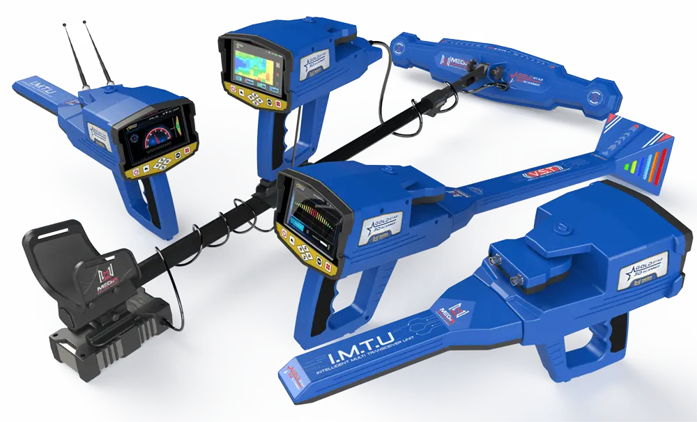
Gold Star 3D Scanner is considered the most complete device in terms of functionality and applications
that can be used for, thanks to the eight search systems available in the device that provide beginners
and professional prospectors alike with all the tools necessary to find buried treasures and ancient monuments.
Gold Star 3D Scanner is the first device from the German company in which the ground scanning technology
has been integrated in order to provide a powerful search mechanism with guaranteed results, with visual results
displayed on the device’s screen or via a tablet bundled with device.
Gold Star 3D Scanner Features
Latest Metal Detection Technologies
Gold star 3D Scanner includes a variety of metal detection technologies and the latest German technology in this field
through measuring tools, 3D ground surveying and long-range detection through several probes, sensors and antennas.
Here we list available tools:
IMTU (Intelligent Multi Transceiver Unit)
This unit is installed at the front of the Gold Star 3D Scanner device and its function is to send electromagnetic waves
at a high frequency in the direction in which the user is searching.
These signals intersect with the electromagnetic fields emanating from underground metal targets and turn into reflected
signals that are received through antennas and the signal is converted after being processed into digital signals.
VST (Vertical High Signal Transceiver)
It is a sensor installed via a special connection at the front of the device. The sensor captures the magnetic field signals
resulting from various buried metal targets (precious such as gold and non-precious such as iron, for example).
The sensor is characterized by the presence of a quadruple cone at its end that contains on both sides a rows of light emitting diodes (LED)
that light up in different colors according to the received signals and the nature of the target
(example: the LEDs will light up in a red color if the VST probe passes over a metal target such as gold or copper).
The signals captured through the sensor are transformed into digital signals that are processed and displayed on the device screen
or the tablet screen in the form of a colored graph that reflects the nature and type of potential target’s metal.
MULTI GROUND SCANNER (M.G.S.60)
It is the probe that is used to conduct a 3D imaging scan of the ground in search for metal targets and potential treasures,
and it has included the latest patented ground scanning technology from the German company Mega Detection and includes
the feature of covering a larger area when scanning at each point, which ensures that the prospector reduces time and effort ,
and to ensure a more accurate result compared to the point-type scanning sensors available in other devices.
8 Search Systems
Gold Star 3D Scanner is the first device in the world that includes 8 search systems with multiple search technologies,
including long-range detection systems, 3D imaging scanning and other technologies.
The eight search systems provide multiple ways to search for different types of metal targets, ancient and
archaeological treasures at different and deep depths.
The appropriate search system can be used for the purpose of the search, and more than one search system
can be used to ensure more reliable and accurate results.
The device includes the following search systems:
1 – Long Range Manual System / MANUAL LRL /
To use this system, the user must install the IMTU as well as the antennas.
The manual system means the possibility of adjusting the long-range scanning settings manually
according to the user’s preferences, before actually conducting the search.
Here are the settings that can be adjusted:
- Target
The type of metal of the targets to be searched can be set from a list that includes search programs
for all types of metals like: Gold – silver – copper – iron – diamonds – platinum – bronze …

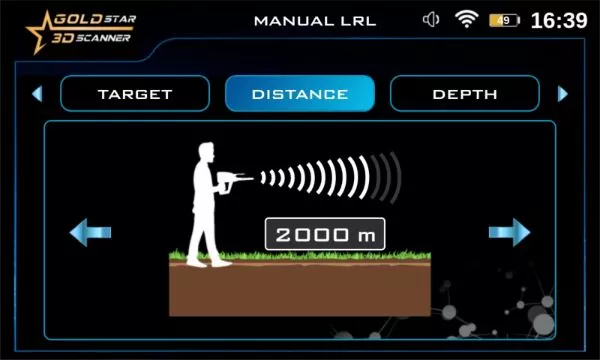
- Distance (Front Scan Range)
It is the distance that expresses the maximum range that the device scans for different targets
and can be set according to specific values within the range from 0 to 3000 meters
(250 – 500 – 750 – 1000 – 1250 – 1500 – 1750 – 2000 – 2250 – 2500 – 2750 – 3000 m)
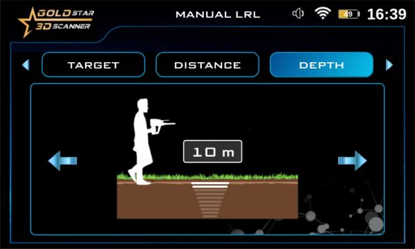
- Depth
This value specifies the maximum depth to search for targets within it through the
current search settings, and can be set in the 0 to 50 meters range.
After setting the previous options, the device searches for targets within the selected scanning
field and depth, the search screen appear that displays a compass-shaped indicator whose
pointer points to the direction of the device (north or south …) and also displays within the same
screen a semicircular indicator that expresses the direction of movement of the two antennas,
as the direction of the cursor changes according to their movement when searching.
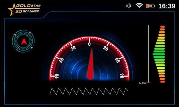
Among the important features that allow the user to correctly adjust the angle of inclination of the device
with respect to the horizon is the gradient tilt indicator on the right of the screen, the green color indicates
the correct acceptable values and the red color for the wrong values of the inclination angle.
2 – Automatic Long-Range System / AUTO LRL /
The IMTU unit, as well as the antennas, are used to search for signals of potential targets within the scanning field.
The difference from the manual long-range system is that in the automatic system, the device performs a fully
automatic scan in search of potential metal targets within the search range.
So, the user only has to choose the system from the list and the device will scan and update the data on the display
screen automatically so that it includes automatically leading the user towards the target location, and the user can
choose to show the following options from the screen (in the form of tabs):
- Target type
Here, the metal type of the buried target is shown , user can select from following target types:
Gold Treasure- Gold Ore – Silver – Copper – Platinum – Bronze – Iron – Diamond – Gemstones – Gold Veins – Cavity..
- Distance
This value is the front scan range distance, and can be set to any value in 0 – 3000 m
- Tracking Target (Direction)
It is an indicator displayed in the form of a semicircle with a pointer indicating the possible direction that the user should follow to reach the target buried underground
- Depth
It presents value of the depth range , and can be set in 0-100 meter range.

- Report
This option provides the ability to display a report that includes a summary of the target’s characteristics
including previous values (distance – depth …)

3 – Long Range Control System / CTRL LRL /
This system provides an unprecedented feature in long-range metal detectors as it enables the user to control
the frequency of searching for different metals, i.e. allocating the frequency value accurately to detect a specific
type of metal, for example gold – copper or any other metal alloys.
The user can adjust a set of related settings before performing the search process, namely:
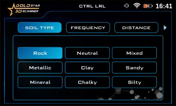
- Soil Type
Soil type refers to the nature of the soil in the land being searched, and predetermined soil types can be chosen:
rocky soil – sandy soil – clay soil – neutral soil …
- Search frequency
Here, the search frequency value is precisely adjusted according to the type of metal to be found
within a specific frequency range (the frequency value is measured in MHz)

- Distance
In addition to the frequency, the scan distance can be set in the forward direction by choosing
a value from predefined values within the range 0 to 3000 meters (250 – 500 – 750 – 1000 – 1250 – 1500 – 1750 – 2000 – 2250 – 2500-2750 – 3000)
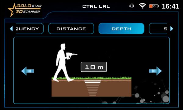
- Depth
To limit the search for targets within a specific search depth, the value is set here
by choosing a value within the range between 0 to 50 meters
After setting the previous settings, the user can start searching and the device will move to the target tracking screen,
which includes the semicircular indicator that represents the direction of movement of the antennas (explained earlier).
4 – Ionic system / IONIC /
The Ionic System includes a completely new search technology to search for signals from ionic fields resulting
from long-buried metal targets thanks to the previously mentioned IMTU.
This unit ensures receiving ionic field signals with greater accuracy, with the ability to control some signal settings
to reach accurate results, and after capturing the signals, they are digitally processed inside the device.
After starting the search by the user, the following information is displayed on the screen:
- Signal strength indicator
This indicator is a bar graph with a gradient bar that varies in terms of length
and color according to the strength of the captured signal related to the target distance, the nature of the terrain, and other factors.
- Signal Sensitivity Indicator
It is a circular indicator that displays the signal sensitivity as a percentage value,
for example 60%, and this value can be changed by the user
- Signal Gain Indicator
It is a circular indicator similar to the previous one that represents the signal strength according
to a value represented as a percentage between 0 – 100% and can also be adjusted.
- Target Depth Icon
It is an icon displayed on the top left of the screen, and by clicking on it, the target depth
measurement screen is shown, which provides a visual depth measurement process for the buried target.
- Save Icon
By clicking on this icon at the top right of the screen, the search results
are saved as a file in the device’s memory according to the selected values.

5 – Bionic System / BIONIC /
This search system is very similar to the Ionic Search System as it uses the same IMTU for conducting searches and work in similar way.
But the difference here is that the search is directed according to predefined signals that are captured by directing the IMTU towards
a target made of a metal, for example gold or silver, and in this case the search unit will only capture similar signals and ignore other ion field signals.
In other words: in the ionic search system, the search is random and free to search for any kind of targets.
In the bionic system, the search is directed according to predefined signals, and this is better and faster for the prospector.
Likewise, the search screen displays the same previous options:
- Signal Strength indicator
- Sensitivity Indicator
- Gain Indicator
- Depth Icon
- Save Icon
it has the same functions that were explained in the ionic system.
6 – Live Stream System
This system is an advanced scanning system that measures the changes in magnetic fields via a high-vertical transmitter and receiver unit or VST.
The sensor is moved after being installed vertically on the ground and the sensor picks up the signals of any metal target present under the ground,
whether it is magnetic metal such as iron or precious metal such as gold and copper.
The probe contains at its conical end, on either side, a group of colored LED lights that change their lighting according to the type of target
, as it lights up in red, for example in case of the target that the probe passes over it, is a precious metal, such as copper or gold.
The signals of the magnetic fields captured on the device screen can be represented directly in the form of a continuous color flow
that changes color depending on the type of metal that the sensor passes over, where green represents normal soil, yellow color is metal and red color is gold

The user can also choose to represent the signals on the bundled tablet through the installed application (android app),
where it displays a changing color gradient similar to the chart on the screen with the same color legends.
7 – Ground Scan System
It is a powerful and accurate imaging system and the first of its kind in Mega Detection devices.
The deep scanning of the ground is performed through a specially designed probe with powerful built-in sensor
called the Multi Ground Scanner or MGS60 for short.
The scanner includes a relatively large scanning surface that ensures coverage of larger area of ground
when perform scanning at each scanning point, thus making the scanning process faster for a large area
compared to the point probes available in traditional ground scanners.
To conduct a ground scan, the process can be controlled and the results can be viewed either via
the device screen or via the tablet device via the analysis application installed on it.
1 – In the case of choosing the first option (on the device), the device will provide,
via its screen, the ability to adjust the scan settings according to the screens that appear sequentially, namely:
- Scanning Mode
present how to perform the scanning process, either manually by recording each scan point
manually or automatically by the device according to a specific time or a certain distance.
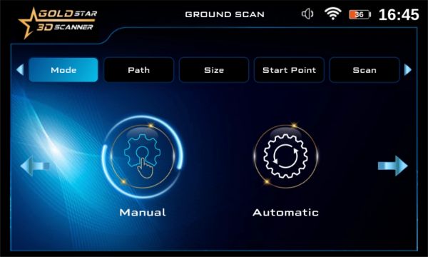
- Scanning Path
There are two options available, the first of which is a One Direction mean parallel scanning lines, including
a spacing (usually 30 cm) , the second is Zigzag, meaning that the next scan line starts at the
end of the previous line while leaving a spacing.

- Size
These values express the method for dividing the scan area to be scanned with MGS,
as the area is theoretically divided into cells, the Width and Hight values indicate the number
of rows and columns of scan area (or lines count and steps count).
For example, in the case of choosing 4 and 5 , there will be 20 cells for the scan area( scan lines = 4 , steps = 5)

- Starting Point:
It presents the point from which the scan is started.
There are two options to start from the right (the lower right corner of the rectangular scanning area)
or start from the left (the lower left corner)
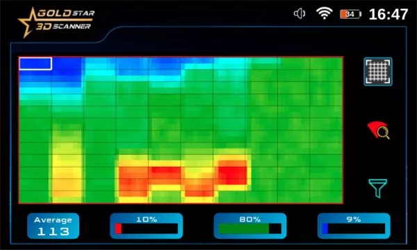
After adjusting the previous settings, the results screen is displayed and includes a rectangular area divided into cells
according to the number of columns and rows previously specified, as each cell represents one scanning point,
and with the scanning by the user, each cell is filled with a specific color according to the area that the scanner passes over,
and each color has a specific indication, Example: The blue color represents a void, and the yellow color is a precious metal … etc.
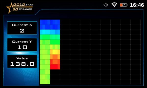
The results screen also contains three rectangular indicators in three colors that express the percentage of the presence
of each type of targets within the specified cell, and these indicators are: the red indicator indicates the proportion
of ferrous (magnetic) metals – yellow indicates the percentage of precious metals (non-magnetic) – the blue the percentage of cavity.
A numeric value representing the target type is also displayed, and also the target depth value within the specified cell.
2 – In the case of tablet the search and scanning settings that were previously detailed are controlled similarly through
the installed analysis application and after setting the options, the scanning is done via the MGS scanner and the scanning
results are displayed on the tablet screen within the application, and here the scanning data is represented in the form of a 3D drawing.
In multiple colors, the drawing expresses the composition of the scanned ground and its contents from different
targets (minerals – natural ground – spaces and tunnels – gold boxes …) and each type has a different color similar to the above (blue for voids, yellow for metals …).
The analysis app on the tablet gives the prospector more accurate possibilities to analyze the detected targets
and know detailed information such as the metal type, depth and location within the scan area.
8 – Pinpointer System
This system is used to perform a fast, accurate and direct scan through the VST, as it measures the changes
in the magnetic field in a region and displays on the device screen a curve that is in the case of receiving metal signals
consisting of rectangles facing upwards of different lengths gradient from green to red in the middle at the maximum
values and then gradient green with lower values on both sides of the chart.
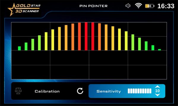
In the case of receiving signals of spaces – such as a tunnel or a basement – the curve consists of rectangles facing
downward of varying lengths gradient from green to dark blue in the middle at maximum values, and then gradient
towards green with lower values on both sides

On the screen of the Gold Star 3D Scanner device, it is possible to control some values that affect the scanning process,
such as the value of sensitivity and ground balance, and the scan result can also be saved.
Integrated Results Display & Feedback System
Gold Star 3D Scanner provides the user with the best integrated system to display the results resulting from the various search technologies included within the device.
This integrated system provides comprehensive and complete information for the prospector about the nature of buried targets and all their details.
The results display & feedback system combines an integration between sound, image and light to provide the best experience for the prospector. this is done through the following tools:
Colored LCD Screen
The main unit includes a high-definition color liquid crystal display (LCD) screen with a large size that secures
a better view when adjusting the various settings such as selecting the search system and the ground scanning
settings and provides reading numbers and charts representing the results clearly.
Gold Star 3D Scanner ‘s screen provides visual presentation of the results within the device’s program with
useful information for the prospector, including the direction of search and a report on the type of metal,
like in long-range systems, and a two-dimensional representation of the scanning area and its contents
of possible targets in the imaging systems.
Android Tablet & Analysis App
Gold Star 3D Scanner comes bundled with a tablet computer running on an Android system and a pre-installed 3D analysis app
to visually represent the results resulting from the scanning in the imaging systems in the form of a multi-color three-dimensional
graphics, which gives the prospector the ability to analyze the data and know all the information about the detected targets
such as depth and precise location , through the tools it provides with an easy and simple interface that enables the prospector
to analyze the graphics to obtain detailed information about all the targets within the scan area.
Sound Feedback
Most of the search systems available in the Gold Star 3D Scanner device provide an audio output through audio tones
via built-in speaker, the audio tones direct the user and give him an idea about the progress of the search process.
Example: In a live stream system, the device emits sounds related to the type of target metal, and the sound intensity
varies according to the proximity and distance from the target.
Light Feedback
VST sensor, which is used in the PINPOINTER and LIVE STREAM search systems, contains LED lights that illuminate
in a variable color according to the type of the target near the sensor (iron or metal, precious metal or space)
and this provides the prospector with an idea about the type of target.
Easy to Use Multi-Language Program
Gold Star 3D Scanner software program is designed according to the latest design standards for modern user interfaces
and user experience with a modern, attractive and practical design that combines clear texts, expressive icons, consistent colors, and animation.
The program provides an easy-to-use experience for beginners and professionals alike, as they enable them to set various search-related settings
such as search systems, search programs, depth field and forward distance in long-range systems, ground scanning settings, and others.
Gold Star 3D Scanner program provides a visual display of the search results for most of the eight search systems and their various
options in the form of graphics, charts and indicators accompanied by the various sounds that are associated with choosing
a specific button or moving between settings and others.
One of the important features of Gold Star 3D Scanner program – to provide access to the largest segment of prospectors around the world
is its availability in 12 international languages that represent the most widespread languages in the world (English – French – Spanish – Arabic – Chinese …)

Powerful External Battery
Power is supplied to the device through a 12-volt lithium-ion rechargeable battery,
designed with a special design in the form of an external box with an on / off button.
Gold Star 3D Scanner battery guarantees a long operation time, that is related to several factors,
including the search system, the search tools used, and the power saving settings available in the device program.


 CONTATTACI PER IL PREZZO SCONTATO DEL GIORNO
Recensioni
Ancora non ci sono recensioni.